Geospatial AI Companies
Explore 2 Geospatial AI companies in our AI directory. Leading companies include Preligens, Kepler.gl.

Preligens
Paris, France
Preligens develops TerraStation, a geospatial AI platform that automatically detects, identifies, and geolocates objects of interest within satellite and aerial imagery. Their core innovation lies in applying deep learning models – specifically foundation models trained on massive datasets of geospatial data – to deliver rapid, scalable analysis for change detection, pattern-of-life monitoring, and critical infrastructure assessment. Preligens primarily serves defense, intelligence, and critical infrastructure stakeholders, and was recently awarded a contract by the French Ministry of the Armed Forces to enhance its intelligence capabilities with automated geospatial analysis.
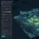
Kepler.gl
San Francisco, United States
Kepler.gl is a leading open-source geospatial analysis tool built on WebGL, enabling users to visualize and explore large-scale datasets – up to billions of rows – directly within a web browser. Its key innovation lies in its data-agnostic architecture and high-performance rendering engine, allowing for rapid visualization of diverse geospatial data formats without requiring specialized hardware. Originally developed at Uber for visualizing massive ride-sharing data, Kepler.gl is now widely adopted by researchers, urban planners, and data scientists for applications ranging from mobility pattern analysis to environmental monitoring.